Creative PowerPoint Country Maps PPT Presentation

Gray country map with location markers labeled with transportation modes, paired with descriptive text on the right.
P.ID : 10692
    183 views
    1 Downloads
    Get Custom Slides by Experts
    Instantly Access Templates in PowerPoint

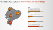
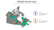
    Country Map for World Tour Plan Presentation


    Boost your presentations with our dynamic "Country PowerPoint Template and Google Slides Themes." Crafted with meticulous detail, this template features a five-node design, each representing a mode of travel—whether it's by airplane, car, ship, bicycle, or bus. With captivating map backgrounds, every node offers a canvas for your ideas to take flight. Perfect for educators, business professionals, and travel enthusiasts alike, this template empowers you to showcase your content with flair. Seamlessly blending aesthetics with functionality, our template ensures your message resonates with your audience. Transform mundane presentations into captivating journeys and leave a lasting impression.Download your audience's attention and command the room with our innovative template today!


    Features of the Template


    • 100 % customizable slides.
    • The slide show is in 4:3, 16:9, zip format.
    • There is powerful connectivity with Google Slides and PowerPoint.
    • It is simple and quick to alter the slide's color.
    • An efficient template that can be easily accessed immediately.
    • Well-crafted template with an instant download facility.
    Advertisement

    You May Also Like These PowerPoint Templates

    Add to Wishlist
    Download
    AI Customize
    Outline of a world map showing the seven continents labeled.
    Add to Wishlist
    Download
    AI Customize
    Slide showing a map of North and South America with regions color-coded and information blocks.
    Free
    Add to Wishlist
    Download
    AI Customize
    Africa map in the center with colorful sections and four text sections with percentage markers around it.
    Add to Wishlist
    Download
    AI Customize
    Indonesia map slide with various color-coded regions and space for text annotations.
    Add to Wishlist
    Download
    AI Customize
    Precise Oregon State County Map PPT Template Presentation
    Free
    Add to Wishlist
    Download
    AI Customize
    World map in red, showing labeled continents and oceans, set against a white background.
    Free
    Add to Wishlist
    Download
    AI Customize
    Fillable US map slide with state abbreviations and a text box for content, including a circular flag graphic.
    Add to Wishlist
    Download
    AI Customize
    PowerPoint slide showing Myanmar's location on a map, with detailed information about the country.
    Add to Wishlist
    Download
    AI Customize
    World map continents and oceans slide featuring a detailed map highlighting all continents and oceans on a blue backdrop.
    Add to Wishlist
    Download
    AI Customize
    Two grey Malaysia map outlines with colorful markers in green, red, yellow and blue, with two percentage areas at the bottom.
    Add to Wishlist
    Download
    AI Customize
    Bangladesh map slide deck featuring green illustrations, flag symbols, and demographic data visualizations.
    Add to Wishlist
    Download
    AI Customize
    World map slide featuring different colors for each continent, with black and white markers and continent labels.
    Add to Wishlist
    Download
    AI Customize
    Map of Pakistan in green with male and female population percentages, represented by circular icons, on either side.
    Add to Wishlist
    Download
    AI Customize
    Illustrated map of Mexico with various icons like maracas, chili peppers, and a guitar representing cultural items.
    Add to Wishlist
    Download
    AI Customize
    Slide deck cover featuring Iran map infographics and slide previews with charts and map data.
    Add to Wishlist
    Download
    AI Customize
    Comparison map slide showing data for the U.S. and Brazil, with 67% female and 33% male with colorful icons and data.
    Add to Wishlist
    Download
    AI Customize
    Illustrated map of Scandinavia with countries highlighted in different colors with caption area for each.