Free - Editable Canada Maps PowerPoint Templates & Google Slides
Free


Best Canada Map Presentation Template
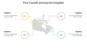
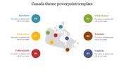
Discover the editable Canada maps in our Google Slides Themes, designed to enlighten your presentations with geographical clarity. The map of Canada stands out on the slide, inviting you to explore the vast landscapes and dynamic cities of this majestic country. Two human icons interact, symbolizing collaboration and connection across Canada's diverse regions. Circle points highlight key locations, inviting your audience to delve deeper into the country's rich history, culture, and economic opportunities. Personalize the maps with your own markers, annotations, and labels to create a truly unique and informative presentation. Unleash your creativity and share your Canadian insights with impact.
Feature of the template
- 100% customizable slides and easy to download.
- Slides are available in different nodes & colors.
- The slide is contained in 16:9 and 4:3 format.
- Easy to change the slide colors quickly.
- Well-crafted template with an instant download facility.


You May Also Like These PowerPoint Templates
Add to Wishlist
Download
Edit


Add to Wishlist
Download
Edit

Add to Wishlist
Download
Edit

Add to Wishlist
Download
Edit


Add to Wishlist
Download
Edit

Add to Wishlist
Download
Edit

Add to Wishlist
Download
Edit

Add to Wishlist
Download
Edit

Add to Wishlist
Download
Edit

Add to Wishlist
Download
Edit

Add to Wishlist
Download
Edit


Add to Wishlist
Download
Edit

Add to Wishlist
Download
Edit

Add to Wishlist
Download
Edit


Add to Wishlist
Download
Edit
