Free - Continents and Oceans Map PowerPoint and Google Slides
Free

Attractive Continents And Oceans Map Presentation Slides
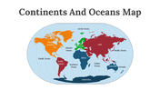
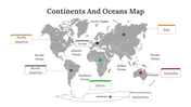
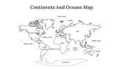
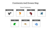
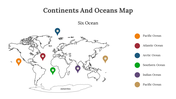
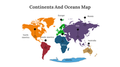
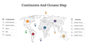
The Continents and Oceans Map is an essential tool for learning about geography. The map consists of seven continents: North America, South America, Europe, Asia, Africa, Australia, and Antarctica, and five oceans: the Atlantic, Pacific, Indian, Southern, and Arctic oceans. This map is useful for students and teachers alike, as it helps in understanding the global geography, including the location of countries, landforms, and bodies of water. The Continents and Oceans Map is also helpful for travelers and researchers to plan their trips and study the earth's diverse features. With our templates, you can create a high-quality presentation that will leave a lasting impression on your audience about the map.
Features of the template:
- 100% customizable slides and easy to download.
- Slides are available in different nodes & colors.
- The slide contains 16:9 and 4:3 formats.
- Easy to change the colors of the slide quickly.
- Highly compatible with PowerPoint and Google Slides.
- Well-crafted template with an instant download facility.


You May Also Like These PowerPoint Templates
Free
Add to Wishlist
Download
AI Customize


Free
Add to Wishlist
Download
AI Customize


Add to Wishlist
Download
AI Customize

Add to Wishlist
Download
AI Customize

Add to Wishlist
Download
AI Customize

Add to Wishlist
Download
AI Customize

Add to Wishlist
Download
AI Customize

Add to Wishlist
Download
AI Customize

Add to Wishlist
Download
AI Customize

Add to Wishlist
Download
AI Customize

Add to Wishlist
Download
AI Customize

Add to Wishlist
Download
AI Customize

Add to Wishlist
Download
AI Customize

Add to Wishlist
Download
AI Customize

Add to Wishlist
Download
AI Customize

Add to Wishlist
Download
AI Customize

Add to Wishlist
Download
AI Customize


Add to Wishlist
Download
AI Customize

Add to Wishlist
Download
AI Customize

Add to Wishlist
Download
AI Customize


Add to Wishlist
Download
AI Customize


Add to Wishlist
Download
AI Customize

Add to Wishlist
Download
AI Customize

Add to Wishlist
Download
AI Customize


Add to Wishlist
Download
AI Customize

Add to Wishlist
Download
AI Customize

Free
Add to Wishlist
Download
AI Customize

Add to Wishlist
Download
AI Customize

