Best Australia Infographics PowerPoint And Google Slides

Australian map is divided into vibrant sections representing different states and territories, each labeled with numbers.
P.ID : 69428
    195 views
    28 Downloads
    Get Custom Slides by Experts
    Instantly Access Templates in PowerPoint

    Amazing Australia Infographics Presentation Slides


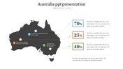
    Explore the land Down Under like never before with our Australia Infographics Presentation Templates! Dive into a world of stunning visuals and engaging content that brings the beauty and richness of Australia right to your fingertips. From quirky kangaroos to the vast Outback, these templates are your passport to discover Australia's fascinating facts, captivating history, and unique culture. Whether you're a curious kid or an inquisitive adult, our templates make learning about this incredible country a breeze. So, why wait? Start your Aussie adventure today with our Australia Infographics Presentation Templates and say, "G'day" to knowledge and fun!


    Features of this template:

    • 100% customizable slides and easy to download.
    • Slides available in different nodes & colors.
    • The slide contained 16:9 and 4:3 format.
    • Easy to change the slide colors quickly.
    • Well-crafted template with instant download facility.
    Advertisement

    You May Also Like These PowerPoint Templates

    Add to Wishlist
    Download
    AI Customize
    Africa PowerPoint template featuring a color coded map, dividing the continent into yellow and green regions for clarity.
    Add to Wishlist
    Download
    AI Customize
    World map infographic with countries in blue and a table listing sessions, goals, conversion rates, and bounce rates.
    Add to Wishlist
    Download
    AI Customize
    Country maps of the UK, Germany, and Italy in blue, red, and green, each labeled with percentage progress bars.
    Add to Wishlist
    Download
    AI Customize
    World map with regions highlighted in yellow, green, and pink, representing South America, Europe, and Australia with text.
    Add to Wishlist
    Download
    AI Customize
    World map slide showing labeled continents and oceans from North America, Asia, Africa, Australia, and Antarctica.
    Add to Wishlist
    Download
    AI Customize
    World map PowerPoint slide highlighting North America, Europe, Russia, and China with respective population data.
    Add to Wishlist
    Download
    AI Customize
    Color coded North America map highlighting Canada, the U.S., and Mexico, with an economic statistics table.
    Add to Wishlist
    Download
    AI Customize
    China map illustration showing multiple regional divisions, by percentage breakdown in three pie charts.
    Add to Wishlist
    Download
    AI Customize
    Simple Europe map template for PowerPoint presentations
    Add to Wishlist
    Download
    AI Customize
    PowerPoint template showing a map of the United Kingdom with a highlighted area in orange on a dark backdrop.
    Add to Wishlist
    Download
    AI Customize
    Gray Europe map with a red highlighted France, marking Paris with a location pin and placeholder text on the left.
    Add to Wishlist
    Download
    AI Customize
    Editable Map Of Australia PowerPoint Presentation
    Add to Wishlist
    Download
    AI Customize
    Blue map of Australia with the UK flag overlaid, and text detailing on the right, set against a white backdrop.
    Add to Wishlist
    Download
    AI Customize
    Color-coded map slide of Australia with major states and territories, including Western Australia, Queensland, and Tasmania.
    Free
    Add to Wishlist
    Download
    AI Customize
    Australia map split into colored sections, highlighting states with green, grey, maroon, red, and yellow areas with captions.
    Add to Wishlist
    Download
    AI Customize
    Slide featuring a map of Australia with data points highlighted, displaying percentages at various locations text area.
    Add to Wishlist
    Download
    AI Customize
    Australia map with five colored states and markers with population data and corresponding numbered captions on the left.