MILESTONE 🌟 5 Million+ creative minds trust SlideEgg! Grab 80% OFF

Google Slides United States Map and PowerPoint Template

A United states map highlighting major cities like new york, los angeles, chicago, and washington with icons and text.
P.ID : 65980
    323 views
    33 Downloads
    Get Custom Slides by Experts
    Instantly Access Templates in PowerPoint

    United States Map Presentation Slide

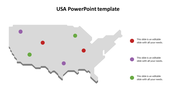
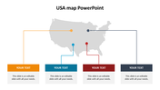
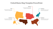
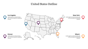
    The United States is an important nation in the world, with its economy and political influence extending beyond its borders. It is a leader in science, technology, and innovation, and its military is one of the most powerful in the world. Its culture has been hugely influential, and its people are known for their openness and freedom. By using our map template you can quickly present geographical information. The four most important cities of the US are highlighted here with location tags to speak more about these cities.

    Features of the template

    • 100% customizable slides and easy-to-download
    • Slides are available in different nodes & colors.
    • The slides contain 16:9 and 4:3 formats.
    • It comes with four nodes.
    • Easy to change the slide colors quickly.
    • It is a well-crafted template with an instant download facility.
    • We designed this slide with a creative theme.
    • You can use this in Microsoft PowerPoint.
    Advertisement

    You May Also Like These PowerPoint Templates

    Free
    Add to Wishlist
    Download
    AI Customize
    Attractive Portugal Map PPT Slide Presentation
    Add to Wishlist
    Download
    AI Customize
    Brazil map slide with location markers for Roraima, Rondonica, Para, Sao Paulo, and Bahia with percentages and captions.
    Add to Wishlist
    Download
    AI Customize
    Argentina map PowerPoint slide with colorful text boxes for adding regional information.
    Add to Wishlist
    Download
    AI Customize
    USA map highlighting California, Texas, and Missouri with location markers and captions for each state.
    Free
    Add to Wishlist
    Download
    AI Customize
    Blue toned Statue of Liberty background on the left with a red wavy border and white space for text with star icons.
    Add to Wishlist
    Download
    AI Customize
    Map of the United States with highlighted states and colorful markers from Oregon to Tennessee with captions.
    Add to Wishlist
    Download
    AI Customize
    Slide showing a gray map of the USA with colored markers for four cities, each matched with a text on the right.
    Add to Wishlist
    Download
    AI Customize
    Map of the US, showcasing highlighted states like WA, SD, and NC, paired with captions and data percentages.
    Add to Wishlist
    Download
    AI Customize
    South America map with color coded countries and markers, alongside six numbered icons, on a dark background.
    Add to Wishlist
    Download
    AI Customize
    USA map infographic with gray outline, featuring population percentage, and colorcoded demographic bars.
    Add to Wishlist
    Download
    AI Customize
    Highlighted U.S. states, including Washington, California, Texas, and Florida, with text placeholders on the right.
    Add to Wishlist
    Download
    AI Customize
    USA PowerPoint slide featuring a map of the United States with states in blue and orange, alongside gender based pie charts.
    Add to Wishlist
    Download
    AI Customize
    United States map with highlighted regions in yellow, red, green, and blue, indicating varying percentage values.
    Add to Wishlist
    Download
    AI Customize
    Blank map of Central America highlighting Guatemala, El Salvador, Costa Rica, and Panama in different colors.
    Free
    Add to Wishlist
    Download
    AI Customize
    USA map slide showing color coded regions and divisions with text placeholder text for each.
    Add to Wishlist
    Download
    AI Customize
    50 states of America slide deck with colorful maps highlighting regions, state names, and vaccination data.
    Add to Wishlist
    Download
    AI Customize
    US time zones slide with color coded maps for pacific, mountain, central, and eastern time, each labeled with numbers.