Map of North America and South America Google Slides Themes

Pack of 22 slides
P.ID : 58938
Advertisement
707 views
110 Downloads
Get Custom Slides by Experts
Instantly Access Templates in PowerPoint

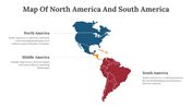
North And South America


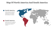
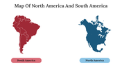
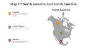
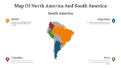
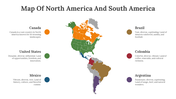
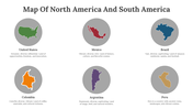
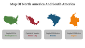
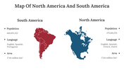
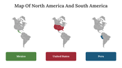
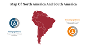
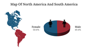
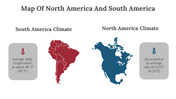
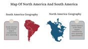
Discover our captivating 'Map of North America and South America Google Slides' template! Perfect for professional and educational purposes, this unique template offers a comprehensive view of the Americas. Explore the diverse geographical features, countries, and iconic landmarks of North and South America, immersing yourself in their rich cultural heritage. Customize each slide effortlessly to fit your needs, with full editing capabilities for content, colors, and layout. Engage your audience with captivating visuals, informative captions, and labeled regions, enhancing their understanding of the North and South America Map. Whether you're an educator, researcher, or business professional, this template is a valuable resource. Don't miss out on this opportunity to create dynamic presentations that inspire and inform. Unlock the potential of the 'Map of North America and South America Google Slides' template today!.

Features Of This Template


  • 100% customizable slides and easy to download
  • Slides are available in different nodes & colors.
  • The slides contained 16:9 and 4:3 formats.
  • Easy to change the slide colors quickly.
  • Well-crafted template with instant download facility.
  • Crisp and elegant font style. 
  • The best template with attractive nodes.

You May Also Like These PowerPoint Templates

Add to Wishlist
Download
AI Customize
Gray USA map template with red, green, and purple dot markers, each linked to corresponding descriptions on the right.
Add to Wishlist
Download
AI Customize
Venezuela map template showing a regional division, with southern areas highlighted in orange.
Add to Wishlist
Download
AI Customize
USA map PowerPoint template with color coded labeled sections for placeholder text on a white backdrop.
Add to Wishlist
Download
AI Customize
Maryland outline map with five cities marked by red dots, each labeled with text boxes.
Add to Wishlist
Download
AI Customize
Gray Argentina map with highlighted regions in red, green, yellow, purple, and pink, each with text labels.
Add to Wishlist
Download
AI Customize
Map of portugal with colored location markers for four cities each with text for descriptions.
Add to Wishlist
Download
AI Customize
Multicolored Switzerland map divided into regions, with six text placeholders, set against a white backdrop.
Add to Wishlist
Download
AI Customize
Paris-themed slide featuring icons of the Eiffel Tower, wine, a windmill, and a map pin on a colorful outline of France.
Add to Wishlist
Download
AI Customize
Slide deck featuring various global and regional map layouts, using icons and markers in diverse colors.
Add to Wishlist
Download
AI Customize
U.S. map with Arkansas marked in red and a location pin and four color-coded text sections with placeholder text.
Add to Wishlist
Download
AI Customize
Canada map slide with percentage markers across regions, option selection, and a bar chart for data representation.
Add to Wishlist
Download
AI Customize
Colorful world map with labeled continents and oceans on a gradient teal background.
Add to Wishlist
Download
AI Customize
Hungary map with different regions in vibrant colors and seven text boxes listing regional names.
Add to Wishlist
Download
AI Customize
Table with six rows of U.S. state data, colored in green, black, and gray, framed by two American flags at the top.
Add to Wishlist
Download
AI Customize
Detailed slide deck showcasing colourful maps of the USA alongside data-driven visual elements.
Add to Wishlist
Download
AI Customize
Slide featuring a labeled map of the United States displaying state borders and two letter state abbreviations.
Add to Wishlist
Download
AI Customize
USA flag themed background slide with stars in a blue backdrop and red and white stripes at the bottom.
Add to Wishlist
Download
AI Customize
USA map highlighting California, Texas, and Missouri with location markers and captions for each state.
Free
Add to Wishlist
Download
AI Customize
Blue toned Statue of Liberty background on the left with a red wavy border and white space for text with star icons.
Add to Wishlist
Download
AI Customize
A map of South America with countries shaded in orange, blue, red, and gray, each paired with icon and captions.
Add to Wishlist
Download
AI Customize
Outline map of south america highlighting major cities including bogota, lima, brasilia, buenos aires, and santiago.
Add to Wishlist
Download
AI Customize
Map of the United States with highlighted states and colorful markers from Oregon to Tennessee with captions.
Add to Wishlist
Download
AI Customize
Slide showing a gray map of the USA with colored markers for four cities, each matched with a text on the right.
Add to Wishlist
Download
AI Customize
Map of the US, showcasing highlighted states like WA, SD, and NC, paired with captions and data percentages.
Add to Wishlist
Download
AI Customize
USA map infographic with gray outline, featuring population percentage, and colorcoded demographic bars.
Add to Wishlist
Download
AI Customize
Highlighted U.S. states, including Washington, California, Texas, and Florida, with text placeholders on the right.
Add to Wishlist
Download
AI Customize
USA PowerPoint slide featuring a map of the United States with states in blue and orange, alongside gender based pie charts.
Add to Wishlist
Download
AI Customize
United States map with highlighted regions in yellow, red, green, and blue, indicating varying percentage values.
Add to Wishlist
Download
AI Customize
Blank map of Central America highlighting Guatemala, El Salvador, Costa Rica, and Panama in different colors.
Free
Add to Wishlist
Download
AI Customize
USA map slide showing color coded regions and divisions with text placeholder text for each.
Add to Wishlist
Download
AI Customize
50 states of America slide deck with colorful maps highlighting regions, state names, and vaccination data.
Add to Wishlist
Download
AI Customize
US time zones slide with color coded maps for pacific, mountain, central, and eastern time, each labeled with numbers.