Free - Incredible South Africa Map PowerPoint Presentation

Free
South Africa map with highlighted regions and three labeled boxes in green, red, and yellow, connected to numbered circles.
P.ID : 65773
    232 views
    101 Downloads
    Get Custom Slides by Experts
    Instantly Access Templates in PowerPoint

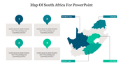
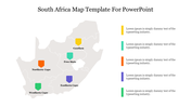
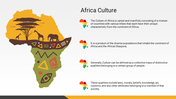
    100% Free Incredible South Africa Map

    SlideEgg offers a free south Africa map template with unique colour themes and backgrounds. Use our Free South Africa Map PowerPoint Presentation template to create an exciting presentation of the provinces of South Africa. It includes the name of the provinces with different shadings. Free to download and use.


    About the template

    The Free South Africa Map PowerPoint Presentation template is a three-noded and free template. It is designed using vibrant yellow, pink and blue color shadings. The map format is very simple to understand and well-designed. It has important features to enhance your presentation. Visit SlideEgg to download more creative Map PowerPoint templates.


    Feature of this Template   

    1. 100% customizable slides and easy to download.

    2. Slides available in different nodes & colors.

    3. The slide is contained in 16:9 and 4:3 formats.

    4. Easy to change the slide colors quickly.

    5. Well-crafted template with instant download facility. 

    6. It is a well-designed presentation template.

    7. Best Africa Map template for creative Presentation.

    Advertisement

    You May Also Like These PowerPoint Templates

    Add to Wishlist
    Download
    AI Customize
    Gray map of Oman with colored regions in blue, green, teal, and yellow, each labeled with a corresponding name.
    Add to Wishlist
    Download
    AI Customize
    Colorful map of Ethiopia slide highlighting four regions with placeholder text.
    Add to Wishlist
    Download
    AI Customize
    Effective South Africa Map PowerPoint Presentation
    Add to Wishlist
    Download
    AI Customize
    Innovative South Africa Map PowerPoint Slide Design
    Add to Wishlist
    Download
    AI Customize
    Map of South Africa showing regions such as Northern Cape, Limpopo, Eastern Cape, and Free State, with placeholder text.
    Add to Wishlist
    Download
    AI Customize
    Customizable South Africa Map PPT Template Slide Design
    Add to Wishlist
    Download
    AI Customize
    Map of Africa with various icons indicating travel locations connected by dotted lines, surrounded by caption areas.
    Add to Wishlist
    Download
    AI Customize
    Africa map template with icons representing various topics and a sidebar showing a seventy statistic.
    Free
    Add to Wishlist
    Download
    AI Customize
    Africa map infographic with four numbered points connected to editable text placeholders on a world map background.
    Add to Wishlist
    Download
    AI Customize
    Africa map outline template highlighting geographic regions, featuring four placeholder text boxes on a white backdrop.
    Add to Wishlist
    Download
    AI Customize
    Outline map of South Africa showing its nine provinces on a white background with a blue frame with a title text.
    Free
    Add to Wishlist
    Download
    AI Customize
    Grey African map with six colored location markers and city names displayed in a layout with text on both sides.
    Add to Wishlist
    Download
    AI Customize
    Gray world map highlighting the Middle East in red and North Africa in purple, with corresponding captions on the right.
    Add to Wishlist
    Download
    AI Customize
    Map of West Africa highlighting Mauritania, Mali, Niger, and Nigeria with colored regions.
    Add to Wishlist
    Download
    AI Customize
    Slide showing a map of East Africa, with each country represented in different colors and labels on the right.
    Add to Wishlist
    Download
    AI Customize
    Map of East Africa highlighting South Sudan, Uganda, Kenya, and Tanzania in distinct colors with caption areas.
    Add to Wishlist
    Download
    AI Customize
    Color coded map of Africa showing the continent's countries labeled with their names.