Editable USA Map PowerPoint and Google Slides with Graph

USA map PPT slide with highlighted states and category data visualization.
P.ID : 33412
    265 views
    24 Downloads
    Get Custom Slides by Experts
    Instantly Access Templates in PowerPoint

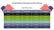
    USA Map Presentation Template

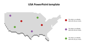
    Looking to jazz up your presentations about the USA? Check out this Editable USA map for PowerPoint! It's super easy to use and customizable. The map PPT has a clean design with red borders on a white background. You can add text right onto the map to share important info, stats, or facts. It's perfect for showing off trends, sales data, or demographics. This serves as a versatile tool for visualizing and communicating spatial data, making complex information more accessible and engaging across various fields.

    Whether you're a business person, student, or teacher, this map is a great tool. You can tweak the text, change the colors to match your theme, and even highlight specific states. Make your presentations pop and keep your audience engaged with this template now available in PowerPoint and Google Slides. Give it a try today and make your presentations shine!

    Features of the template:

    • Slides are available in different nodes & colors.
    • Easy to change the slide colors.
    • Well-crafted template with instant download.
    Advertisement

    You May Also Like These PowerPoint Templates

    Add to Wishlist
    Download
    AI Customize
    Detailed slide deck showcasing colourful maps of the USA alongside data-driven visual elements.
    Add to Wishlist
    Download
    AI Customize
    Slide featuring a labeled map of the United States displaying state borders and two letter state abbreviations.
    Add to Wishlist
    Download
    AI Customize
    USA flag themed background slide with stars in a blue backdrop and red and white stripes at the bottom.
    Add to Wishlist
    Download
    AI Customize
    USA map highlighting California, Texas, and Missouri with location markers and captions for each state.
    Free
    Add to Wishlist
    Download
    AI Customize
    Blue toned Statue of Liberty background on the left with a red wavy border and white space for text with star icons.
    Add to Wishlist
    Download
    AI Customize
    Map of the United States with highlighted states and colorful markers from Oregon to Tennessee with captions.
    Add to Wishlist
    Download
    AI Customize
    Slide showing a gray map of the USA with colored markers for four cities, each matched with a text on the right.
    Add to Wishlist
    Download
    AI Customize
    Map of the US, showcasing highlighted states like WA, SD, and NC, paired with captions and data percentages.
    Add to Wishlist
    Download
    AI Customize
    South America map with color coded countries and markers, alongside six numbered icons, on a dark background.
    Add to Wishlist
    Download
    AI Customize
    USA map infographic with gray outline, featuring population percentage, and colorcoded demographic bars.
    Add to Wishlist
    Download
    AI Customize
    Highlighted U.S. states, including Washington, California, Texas, and Florida, with text placeholders on the right.
    Add to Wishlist
    Download
    AI Customize
    USA PowerPoint slide featuring a map of the United States with states in blue and orange, alongside gender based pie charts.
    Add to Wishlist
    Download
    AI Customize
    United States map with highlighted regions in yellow, red, green, and blue, indicating varying percentage values.
    Add to Wishlist
    Download
    AI Customize
    Blank map of Central America highlighting Guatemala, El Salvador, Costa Rica, and Panama in different colors.
    Free
    Add to Wishlist
    Download
    AI Customize
    USA map slide showing color coded regions and divisions with text placeholder text for each.
    Add to Wishlist
    Download
    AI Customize
    50 states of America slide deck with colorful maps highlighting regions, state names, and vaccination data.
    Add to Wishlist
    Download
    AI Customize
    US time zones slide with color coded maps for pacific, mountain, central, and eastern time, each labeled with numbers.