Practical Map PPT Template for Business Presentations

 Canva
Canva
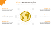
Map PowerPoint Template and Google Slides
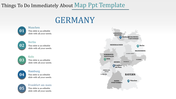
The "Map PowerPoint Template and Google Slides" is an ideal tool for showcasing geographical data and regional analysis. The image displays a map of Germany with four highlighted regions: Bayern, Berlin, Hessen, and Sachsen, each marked with a percentage value in distinct colors.
This template is perfect for presentations related to market analysis, regional demographics, sales reports, or any topic that involves geographic data interpretation. It's particularly useful for businesses, researchers, educators, or policymakers who need to visually communicate regional information.
Designed for professionals in various fields, including business analysts, marketers, geographers, educators, and government officials.
Compatible with PowerPoint and Google Slides. Available in "16:9" and "4:3" formats and zip files for easy sharing. Free and fully customizable, allowing users to modify the map, colors, text, and percentages to suit their presentation needs and preferences. Download it now and captivate your audience with compelling visual representations of regional data and analysis!


You May Also Like These PowerPoint Templates
Add to Wishlist
Download
AI Customize

Add to Wishlist
Download
AI Customize

Add to Wishlist
Download
AI Customize

Add to Wishlist
Download
AI Customize

Add to Wishlist
Download
AI Customize

Add to Wishlist
Download
AI Customize

Add to Wishlist
Download
AI Customize

Add to Wishlist
Download
AI Customize

Add to Wishlist
Download
AI Customize

Add to Wishlist
Download
AI Customize

Add to Wishlist
Download
AI Customize

Add to Wishlist
Download
AI Customize

Add to Wishlist
Download
AI Customize

Add to Wishlist
Download
AI Customize

Add to Wishlist
Download
AI Customize

Add to Wishlist
Download
AI Customize

Add to Wishlist
Download
AI Customize

Add to Wishlist
Download
AI Customize

Add to Wishlist
Download
AI Customize

Add to Wishlist
Download
AI Customize
