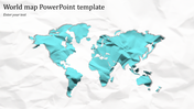
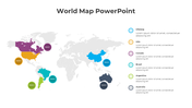
Map PowerPoint Template - North America Map presentation

 Canva
Canva
Visualize Data: Map PowerPoint Template
Present geographic data effectively with our Map PowerPoint template.
Slide Description:
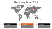
This slide has a clear map of North America, showing Canada, the USA, and Mexico. It also has a space to list big things like growth, how many people live there, and how much money they make over time.
Who should use it?
It's perfect for people who study business, teachers, people who study markets, and anyone who needs to share geography facts in a simple way.
Grab this easy-to-understand Map PowerPoint slide today and share your geography info and changes with ease.
Features of the template
- 100% customizable slides and easy to download.
- The slides contain 16:9 and 4:3 formats.
- Easy to change the colors quickly.
- It is a well-crafted template with an instant download facility.
- It is a 100% pre-designed slide.
- The slide holds vibrant colors.


You May Also Like These PowerPoint Templates
Add to Wishlist
Download
Edit

Add to Wishlist
Download
Edit

Add to Wishlist
Download
Edit

Add to Wishlist
Download
Edit

Add to Wishlist
Download
Edit

Add to Wishlist
Download
Edit

Add to Wishlist
Download
Edit

Add to Wishlist
Download
Edit


Add to Wishlist
Download
Edit

Add to Wishlist
Download
Edit

Add to Wishlist
Download
Edit

Add to Wishlist
Download
Edit

Add to Wishlist
Download
Edit

Add to Wishlist
Download
Edit

Add to Wishlist
Download
Edit

Add to Wishlist
Download
Edit

Add to Wishlist
Download
Edit

Add to Wishlist
Download
Edit

Add to Wishlist
Download
Edit
