MILESTONE 🌟 5 Million+ creative minds trust SlideEgg! Grab 80% OFF

Get innovative Editable World Map PowerPoint Template

World map with location markers and connecting lines showing travel routes between different countries.
P.ID : 2799
    2.2K+ views
    101 Downloads
    Get Custom Slides by Experts
    Instantly Access Templates in PowerPoint

    Editable World Map PowerPoint Template

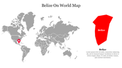
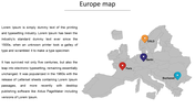
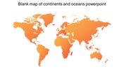
    The "Editable World Map PowerPoint Slides" presents a world map divided into distinct colors, delineating geographical areas. Four customizable pins connected by lines offer an intuitive way to represent travel paths or international connections.

    It is a versatile tool for visualizing travel routes and connections between cities across the globe. With customizable pins and text boxes, this template is ideal for illustrating travel itineraries, showcasing business connections, or enhancing educational presentations.

    Tailored for travelers, business professionals, educators, or presenters seeking to highlight global connections and geographical insights. 

    The template allows seamless editing within PowerPoint, enabling easy customization of pins and text boxes to suit specific presentation needs. Available in PowerPoint format, adaptable to both 16:9 and 4:3 aspect ratios, and conveniently packaged in a zip file for easy sharing and usage. Download the World Map Template to effortlessly illustrate travel routes and global connections
    Advertisement

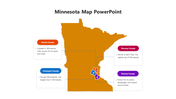
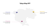
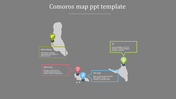
    You May Also Like These PowerPoint Templates

    Add to Wishlist
    Download
    AI Customize
    Indonesia map presentation slide with colorful percentage icons and data with placeholder text.
    Add to Wishlist
    Download
    AI Customize
    Gray outline map of the Netherlands centered with six colored caption boxes in yellow, teal, purple, orange, pink, and red.
    Add to Wishlist
    Download
    AI Customize
    Gray Singapore map with five highlighted regions, and location details on the right with flag in the left corner.
    Free
    Add to Wishlist
    Download
    AI Customize
    World map in light gray with four colored labels highlighting specific areas, with corresponding captions below.
    Add to Wishlist
    Download
    AI Customize
    World map with continents in different colors, labeled North America, South America, Europe, Africa, Asia, and Australia.
    Add to Wishlist
    Download
    AI Customize
    Slide showcasing three world map globes with percentage for business system, suppliers, and community in distinct colors.
    Add to Wishlist
    Download
    AI Customize
    World map infographic with colored pins in blue, green, red, yellow, and teal, each connected to a caption box.
    Free
    Add to Wishlist
    Download
    AI Customize
    Color-coded world map highlighting regions with labeled data percentages in circular overlays.
    Free
    Add to Wishlist
    Download
    AI Customize
    Services slide with a workspace scene on the left, showing a woman writing notes on a desk with a laptop.
    Add to Wishlist
    Download
    AI Customize
    World map PowerPoint slide with percentage circles highlighting different regions with percentages and captions.
    Add to Wishlist
    Download
    AI Customize
    PowerPoint slide featuring a world map with three location markers, each with text boxes.
    Add to Wishlist
    Download
    AI Customize
    World map slide with caption areas linked by horizontal colored lines representing different regions.
    Free
    Add to Wishlist
    Download
    AI Customize
    Blue-themed infographic featuring a globe and three doughnut charts labeled 40%, 60%, and 70%.
    Add to Wishlist
    Download
    AI Customize
    Illustrated Witcher world map with colored continents,  indicating different regions and color-coded caption areas.
    Free
    Add to Wishlist
    Download
    AI Customize
    World map PowerPoint slide with highlighted countries USA, Germany, a number counter, and a pie chart on a white theme.
    Add to Wishlist
    Download
    AI Customize
    Mapa mundi para apresentacao with numbered regions, each displaying a placeholder text on a colorful, interactive map.