Editable Cuba Map PowerPoint And Google Slides Template

 Canva
Canva
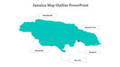

Cuba Map PowerPoint, Google Slides, and Canva Template
Cuba Map Presentation is an essential resource for presenting geographical, demographic, and cultural insights about Cuba. This deck highlights topics such as the country's provincial divisions, major cities like Havana and Santiago de Cuba, regional economic zones, trade routes, tourism hotspots, and key historical landmarks. By using clear vector maps and pinpoint icons, you can illustrate population trends, business expansions, or travel itineraries effectively. Whether for classroom lessons, market entry reports, or travel agency proposals, a Cuba Map Presentation helps deliver clear, engaging visuals that strengthen your narrative.
Purpose Of The Slides
This Cuba-themed map slide is designed to visually support any presentation involving Cuban geography, business data, or travel planning. Each slide uses editable vector maps to showcase provinces, city markers, and customizable legends.
Who Can Use It?
Perfect for educators teaching Latin American studies, business professionals pitching investment opportunities, tourism consultants showcasing travel packages, and students creating reports about Cuba’s culture or economy.
Special Key Features
This slide includes clean vector graphics, adjustable labels, and colorful legends, making it easy to tailor for your topic. The multicolor theme keeps data attractive yet professional. Customizable placeholders allow you to update text and icons quickly. Download our Cuba Map Presentation now and turn facts about Cuba into stunning visual stories. Make your reports stand out with ease and Confidence!
Features of this template
- 100% customizable slides and easy to download.
- The slides contain 16:9 and 4:3 formats.
- Easy to change the colors quickly.
- Highly compatible with PowerPoint, Google Slides, and Canva templates.


You May Also Like These PowerPoint Templates


