Editable PowerPoint Map Template and Google Slides

Africa map PowerPoint slide with colored regions and numbered sections for captions.
P.ID : 14176
    369 views
    21 Downloads
    Get Custom Slides by Experts
    Instantly Access Templates in PowerPoint

    Editable PowerPoint Map Template and Google Slides

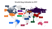
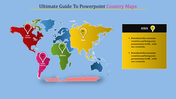
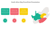
    The "Editable PowerPoint Map Template and Google Slides" is a versatile tool for creating engaging presentations that involve geographic data related to Africa. The image features a map of Africa, divided into five regions, each represented by a different color and labeled with the names of the countries within that region. 

    This template is ideal for presentations that require visual representation of geographic information, such as business reports, academic lectures, research projects, or cultural presentations focusing on Africa. It's perfect for illustrating regional demographics, economic trends, cultural diversity, or geopolitical dynamics.

    Designed for professionals across various fields, including educators, researchers, business analysts, policymakers, and cultural ambassadors.

    Compatible with PowerPoint and Google Slides. Available in "16:9" and "4:3" formats and zip files for easy sharing. Free and fully customizable. Enhance your presentations with this versatile and user-friendly template. Download it now to create compelling visual representations of African geography and data!
    Advertisement

    You May Also Like These PowerPoint Templates

    Free
    Add to Wishlist
    Download
    AI Customize
    Map of Europe with two countries highlighted in maroon and teal, with a circular chart displaying percentages.
    Add to Wishlist
    Download
    AI Customize
    Gray map of Turkey with four highlighted regions in yellow, blue, red, and purple, paired with a legend with color codes.
    Add to Wishlist
    Download
    AI Customize
    South America map displayed on the right side, with detailed text about its history on the left.
    Add to Wishlist
    Download
    AI Customize
    PPT template featuring a bar chart and world map with colored markers, illustrating data across multiple years and regions.
    Add to Wishlist
    Download
    AI Customize
    United States map slide with orange highlight, featuring three numbered captions below, on a black background.
    Free
    Add to Wishlist
    Download
    AI Customize
    World map with highlighted locations and percentage data, paired with four labeled boxes in pink and purple.
    Add to Wishlist
    Download
    AI Customize
    3D world map with five labeled percentage in yellow, orange, blue, and white, connected to text areas, on a dark background.
    Add to Wishlist
    Download
    AI Customize
    Map PowerPoint template highlighting a region in Northern Africa with placeholder text for a description.
    Free
    Add to Wishlist
    Download
    AI Customize
    China map outline with colorful flag markers in red, green, purple, and orange, each linked to text on the right.
    Add to Wishlist
    Download
    AI Customize
    Demographics based PPT slide featuring maps of the United States and Brazil with gender distribution icons and percentages.
    Add to Wishlist
    Download
    AI Customize
    Infographic slide displaying a gray U.S. map with three connected captions, each containing an icon and text.
    Add to Wishlist
    Download
    AI Customize
    Slide featuring Africa map with two percentage markers in orange and four checkmark captions on a dark background.
    Add to Wishlist
    Download
    AI Customize
    South Africa map with color-coded markers, including Mpumalanga and North West, listed with caption areas.
    Free
    Add to Wishlist
    Download
    AI Customize
    Canada map template with labeled provinces and territories on the left and four colorful content boxes on the right.
    Add to Wishlist
    Download
    AI Customize
    Canada map with provinces marked in green, red, yellow, and blue, featuring male and female gender icons.
    Add to Wishlist
    Download
    AI Customize
    Gray geographical map with highlighted regions in teal, labeled with four captions on the left.
    Free
    Add to Wishlist
    Download
    AI Customize
    Global map infographic highlighting countries in blue and green, with two text sections below featuring circular icons.
    Add to Wishlist
    Download
    AI Customize
    Outline map of South Africa showing its nine provinces on a white background with a blue frame with a title text.
    Free
    Add to Wishlist
    Download
    AI Customize
    Grey African map with six colored location markers and city names displayed in a layout with text on both sides.