Creative Germany PowerPoint Presentation Templates

Slide featuring a colorful map of germany with captions for each region on a white backdrop.
P.ID : 48394
    247 views
    25 Downloads
    Get Custom Slides by Experts
    Instantly Access Templates in PowerPoint

    Breathtaking Germany PPT Presentation

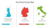
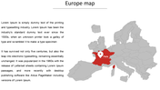
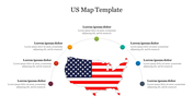
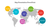
    Germany is a well-known economic power in the world. The nation is a global innovator and is highly regarded for its engineering advancements. Give a brief description of the tour's major cities or stops. This template includes a Germany map icon to help travelers identify the cities they want to visit and get a sense of their entire journey. Six text bubbles are also scattered over the map to indicate critical locations. You can go on a trip that you won't soon forget. Thanks to the easily editable and customizable map! Seize it now!

    Feature of this Template 

    •  The Slides are available in different nodes & colors.
    •  This slide contains 16:9 and 4:3 formats.
    •  It is easy to change the slide colors quickly.
    •  It is a well-crafted template with an instant download facility 
    •  The best PowerPoint theme template.
    •  It is a well-designed Map Presentation template.
    Advertisement

    You May Also Like These PowerPoint Templates

    Free
    Add to Wishlist
    Download
    AI Customize
    PowerPoint template with a USA map, highlighting states and three labeled values in blue circles for a stylish design.
    Add to Wishlist
    Download
    AI Customize
    A highlighted map of Europe on a world map with four colored lines leading to placeholders text.
    Add to Wishlist
    Download
    AI Customize
    A slide showing a gray map of the united states with a small world map highlighting the USA in blue.
    Add to Wishlist
    Download
    AI Customize
     World map with linked circular charts showing varying percentage figures, placed around different regions.
    Add to Wishlist
    Download
    AI Customize
    White South America map with numbered location markers for five countries, connected by faint grid lines, on a blue backdrop.
    Add to Wishlist
    Download
    AI Customize
    World map slide with four colored icons connected by lines, representing different locations and captions below.
    Add to Wishlist
    Download
    AI Customize
    A global map with labeled continents North America, South America, Europe, Africa, Asia, Australia, and Antarctica.
    Add to Wishlist
    Download
    AI Customize
    Canada map PowerPoint template with highlighted regions in orange for a professional presentation.
    Add to Wishlist
    Download
    AI Customize
    Italy maps PowerPoint slides with various color coded regions, each marked with numbered labels on a white backdrop.
    Add to Wishlist
    Download
    AI Customize
    PowerPoint slide featuring a world map with the United States highlighted on a dark backdrop.
    Add to Wishlist
    Download
    AI Customize
    A world map slide with markers labeled A, B, C, and D, each linked to different regions, and captions describing each point.
    Add to Wishlist
    Download
    AI Customize
    Daily coronavirus cases slide with USA map highlighting states in purple, yellow, and red, representing case count ranges.
    Free
    Add to Wishlist
    Download
    AI Customize
    Slide design showcasing a map with a marked yellow area and three circular icons with captions on the right.
    Add to Wishlist
    Download
    AI Customize
    World map PPT slide with country markers, showcasing data percentages for a company with captions on a white backdrop.
    Add to Wishlist
    Download
    AI Customize
    Sweden map infographic with four percentage indicators in blue, yellow, orange, and purple, connected to labeled captions.
    Add to Wishlist
    Download
    AI Customize
    PowerPoint slide featuring a world map with percentage markers on various countries, showcasing country maps.
    Add to Wishlist
    Download
    AI Customize
    Canada map on a blue background with five interconnected circles featuring icons and captions around the map.