Canada Map PPT Template for Detailed Geographic Insights


Canada Map PPT Template and Google Slides
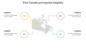
The "Canada Map PPT Template and Google Slides" features an illustrative map of Canada, showcasing its provinces and territories. Each region is clearly labeled with its name and accompanied by a corresponding percentage, providing valuable information or data about each area. The map is thoughtfully color-coded, with distinct colors assigned to different provinces or territories, possibly indicating regional distinctions within the country.
This template is ideal for presentations that involve discussions or analyses related to Canada, its regions, demographics, or socioeconomic factors. It can be utilized in various contexts, including business meetings, academic lectures, research presentations, or geographic studies, to provide visual representations of Canadian territories and facilitate discussions on topics such as population distribution, economic trends, or political landscapes.
Compatible with PowerPoint and Google Slides, ensuring flexibility and ease of use across different presentation platforms. Available in "16:9" and "4:3" formats, as well as zip files, for seamless integration and compatibility with various devices and software. Fully customizable. Download this free template today.


You May Also Like These PowerPoint Templates


Add to Wishlist
Download
Edit

Add to Wishlist
Download
Edit

Add to Wishlist
Download
Edit

Add to Wishlist
Download
Edit

Add to Wishlist
Download
Edit

Add to Wishlist
Download
Edit

Add to Wishlist
Download
Edit

Add to Wishlist
Download
Edit

Add to Wishlist
Download
Edit

Add to Wishlist
Download
Edit

Add to Wishlist
Download
Edit

Add to Wishlist
Download
Edit

Add to Wishlist
Download
Edit

Add to Wishlist
Download
Edit

Add to Wishlist
Download
Edit


Add to Wishlist
Download
Edit
